Explore: The most Pyrenean climb
Not far from the Costa Brava’s coastline and just a few kilometres from the city of Girona, Vallter 2000 is a popular ski resort that is building its own cycling history
This article was produced in association with Costa Brava Tourism
One of the most attractive features of the Girona area and the Costa Brava is its enormous variety of landscapes and the convergence of apparently dissimilar environments, such as the high mountains and the beaches. In fact, in a single cycling trip, we can enjoy all of these contrasts and immerse ourselves in different worlds, as if we were stepping through Alice’s Looking Glass. On this occasion, we will opt for a demanding and tough route that has its opening kilometres in the Pre-Pyrenean region of La Garrotxa, known for its volcanic vegetation and upwards of 30 dormant volcanoes, along with a tough finale on Vallter 2000, one of the region’s iconic climbs.
The route starts from La Garrotxa and rises into the high eastern Pyrenees, reaching the summit of Vallter 2000 before plunging back to the lowlands of Olot. It is 154 kilometres long, and includes 3,200 metres of cumulative ascent, crossing three different landscapes: Mediterranean, Atlantic and Alpine. The route is like a large and varied botanical garden, with stunning views and an incredible mix of challenges and terrain. The main event, and the jewel in the crown of this beautiful ride, is undoubtedly the road to Vallter 2000, a severe, consistent, rough and somewhat hypoxic ascent that every year sees the passage of legions of cycle tourists. It has also become a regular fixture, even the defining feature, of the region’s premier professional bike race, the Volta a Catalunya.
We begin in the town of Sant Esteve d’en Bas, in the region of La Garrotxa; about a 30-minute drive from Girona. Sant Esteve d’en Bas is an enclave of Atlantic aesthetics in the heart of the Mediterranean; it’s a territory where the Pre-Pyrenees can be felt as much as seen. The first few flat kilometres lead us to the county capital Olot, a city that stretches over ancient volcanic lava flows and has a long cultural tradition of religious and pictorial imagery and renowned natural heritage. Its extinct volcanoes and its leafy and expansive beech forests draw tourists from far and wide.
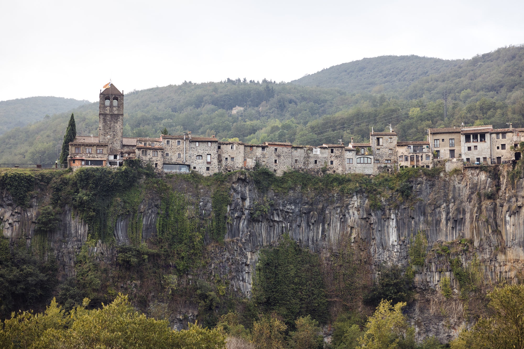
We leave Olot and follow the course of the river Fluvià to Castellfollit de la Roca. This village, perched atop enormous basalt columns, is the gateway to the first major climbs on the route. The ascent towards the Coll de Camporiol takes the rider to higher ground, yet the landscape is still Mediterranean in appearance, like a halfway house between sea and mountains. It is an area of holm oaks, white limestone walls and abrupt and confusing topology. It is the so-called Alta Garrotxa, a land of transition to the real Pyrenees. It is sparsely inhabited, remote and difficult to access. The ascent combines pleasant rolling stretches with ramps of up to 12 per cent.
Arrival at the small village of Oix allows us to relax a little and prepare for the ascent to the Coll del Salomó and Coll de Bucs. This pass has steeper slopes and almost 10km of climbing. After a quick descent, we reach the village of Beget, a small and remote enclave in the Ripollès region. It is constructed on a very human scale: all its buildings are made of exposed stone and its cobbled streets wind their way along the river Llierca, crisscrossing it with a few characterful bridges, too narrow for motor vehicles. The Romanesque church of Sant Cristòfol, whose construction began in the 12th century, is an Asset of Cultural Interest. Equally culturally interesting for the tiring cyclist: Beget has several bars and restaurants.
 The next part of the route is demanding and 12km and 500m of winding, uninterrupted ascent await us. We pass Rocabruna and the Coll de la Boixeda and enter the Camprodon valley. This whole area was witness to the flight of thousands of Republicans during the Spanish Civil War, and it is an area with a rich cultural heritage and a history of events that have marked both the territory and the people.
Camprodon is a tourist town of about 2,500 inhabitants in the heart of the eastern Pyrenees. At the end of the 19th century and beginning of the 20th century, the Catalan bourgeoisie began to spend their summers in places like this. Majestic second homes were built and the wealthiest families spent their summers here, a refuge from the heat of the Catalan capital, Barcelona. Passeig Maristany is one legacy of this glorious period. It is home to a tree-lined avenue with a clear Central European appearance, with buildings by famous architects such as Francesc Durani Reynals, Josep Coderch and Francesc Mitjans. Juan Negrín, prime minister of the Spanish Republic in the late 1930s, even spent the summer in one of these houses.
We start riding the false flat that leads us to the villages of Llanars, Vilallonga de Ter and Setcases, and it is here that the real ascent to Vallter 2000 begins. From Setcases it takes 12km to gain 900m in altitude. At some points the gradient reaches ten per cent, and the average is 7.4. The altitude of the final part of the climb is an indication of its toughness. The arrival at 2,000m is noticeable and our muscles, which are not very well adapted, demand more oxygen than is available.
The climb to Vallter 2000 is tough throughout its length and only a short break at kilometre eight allows us to catch our breath a little. The final part has 11 hairpin bends, dedicated to some of the most famous cycling races in the world. A red stripe crosses the asphalt with the names of the Amstel Gold Race, Flèche Wallonne, Giro di Lombardia, Tour de France, Paris-Roubaix and more. This climb is perhaps the closest ascent of a truly Pyrenean character that one can make from Girona. It is grippy, unpredictable and unrhythmical.
 The history and geography of Vallter 2000 is directly linked to its geological history. It sits in a glacial cirque of Mesozoic origin, surrounded by rocky peaks of almost 3,000m and yet still not far from the Mediterranean Sea. This cirque has been shaped by ice and high mountain weather dynamics for untold millennia and it has become a natural amphitheatre. It is a living lesson in geology. Vallter means high mountain, alpine mountain, mountain of gneiss, mountain of marmots, mountain that grips, mountain of hypoxia, mountain that lends itself to the epic.
The ski resort itself, located in the municipality of Setcases, was conceived and founded in the mid-1970s by the local entrepreneur Jordi Pujol, who made his money in biscuits. He promoted and financed the installation of ski lifts and other skiing facilities, while the asphalted access to the 2,000m-high base of the resort has become one of the most prized ascents for lovers of road cycling.
Reaching the summit of the road at Vallter means we must now turn for the route back to Olot. In our legs we have already accumulated some 80km and 3,000m of ascent. The climbing is all but done, and the remainder of the ride is much quicker and easier. We will retrace our steps along the route to Camprodon, to continue descending at high speed to Sant Pau de Segúries, where we start the last pass of the route.
The Coll de Capsacosta, the old access to the neighbouring region of La Garrotxa, is gentle, undemanding and not very busy, one last reminder of the topography of the area. After a quick descent from the pass, on its southeast side, we pass through Olot again and after a few kilometres of easy flat terrain we reach our starting point, Sant Esteve d’en Bas.
We have been from the plains to the high mountains and back again, all in the space of a few short hours. It’s the kind of ride you can only do in Catalunya.